REMEMBER TO PRINT THESE DIRECTIONS OUT BEFORE YOU LEAVE FOR THE WEDDING
From Scenic Heights Cabin Development
TOTAL TRAVEL TIME: 35 minutes
-Turn RIGHT onto Rogers-Glencairn Rd
-Go 1.9 miles and turn LEFT onto KY-15 N/KY-715 N (Glencairn Road ends at this intersection…not sure if there is a sign for Ky-15/Ky-715, though)
-Go 1.7 miles and turn LEFT onto KY-15/KY-715
-Go .8 mile and turn RIGHT onto KY-715
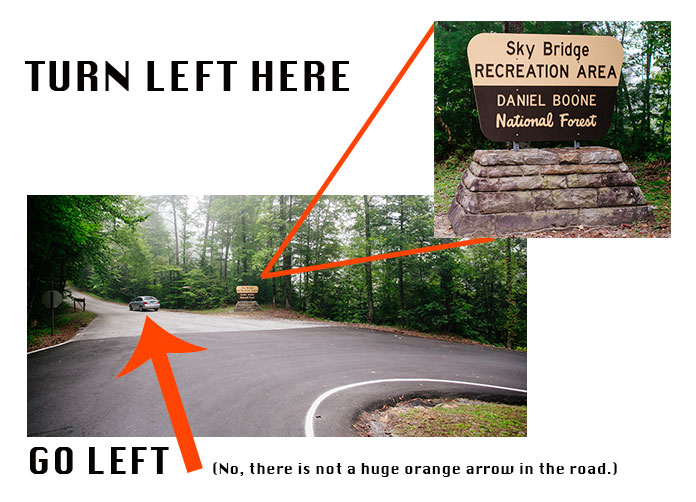
-Go 4.9 miles to SKY BRIDGE RECREATION AREA (look for the sign…see photo below) VERY sharp turn to the right(this is so sharp it goes back in the opposite direction. The turn is on a steep hill)
-DO NOT GO RIGHT…VEER LEFTISH (SEE PHOTO BELOW) If you are on a gravel road, you have turned waaaaaay to early. Sky Bridge Road is a blacktop road.
-Go .1 mile and pull off at the first turn off on the right. You will see a sign for Devil’s Canyon.
-Meet My Tiny Wedding in the parking area. Please do not hike out to the ceremony site. We will have no way of knowing you have arrived and will continue to wait in the parking lot.
Please call if you need help
Rachel 6064816199


.png)
.png)
.png)
.png)
.png)

.jpg)
.png)
.png)
.png)
.png)
.png)
.png)
.png)
.png)